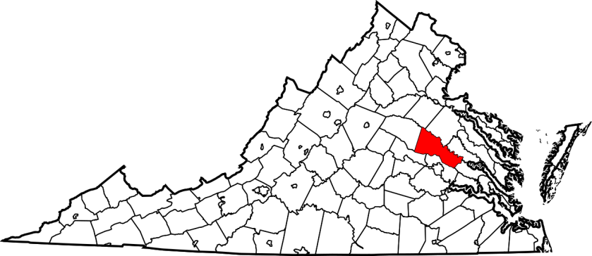
Hanover County was created on November 26, 1719, from the area of New Kent County called St. Paul’s Parish. It was named for the Electorate of Hanover in Germany, because King George I of Great Britain was Elector of Hanover at the time. The county was developed by planters moving west from the Virginia tidewater, where soils had been exhausted by tobacco monoculture.
I don’t have a large number of ancestors who lived in Hanover County. Hanover was kind of a way station for my family; many of them had been residents of New Kent County, but became part of Hanover County when the county was created in 1719. Others lived briefly in Hanover before moving on to counties further west in Virginia or to the Carolinas. I have ancestors on both my mother’s and my father’s side of the family in Hanover County in the first half of the 18th century.
It’s difficult to figure out exactly where my ancestors in central Virginia actually lived. New Kent County, formed in 1654, had no western boundary for 70 years, until Hanover County was formed in 1721. If you lived in this area between 1654 and 1721, you lived in New Kent County. When Hanover County was formed in 1721, it had no western boundary. It would be another 20 years before Louisa County was formed to the west of Hanover County, in 1642. Thus it is possible, and probably even likely, that some of my ancestors who are identified as living in New Kent, then Hanover, then Louisa County, in fact did not move during these years. I’ll talk about New Kent County in Week 31 of this project, on July 31, 2020.
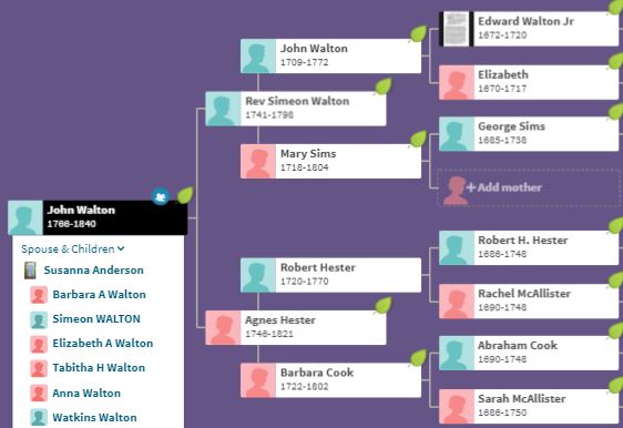
These pedigree charts show my ancestral lines that spent at least some time in Hanover County.

Evolution of the Counties in Virginia
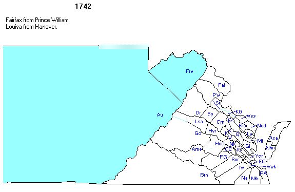
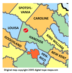
It is important to know when counties were founded in order to know where to look for records. The following sequence of maps (all taken from http://www.mapofus.org) shows this evolution in the central part of Virginia. One important thing to realize about county formation – new counties are established as populations grow, because people need to be able to get to the county seat easily for activities like forming local militias.


Virginia was originally made up of eight “shires,” which immediately began to be called counties. The area that would become Hanover County was part of Charles River County (soon to be renamed York County. New Kent was carved out of York County in 1634


Hanover County was carved from New Kent County in 1721. Hanover County got a western boundary seven years later
A (Very) Little History
To understand evolution of Hanover County, it’s essential to understand the connection between the church parishes in colonial Virginia and the evolution of counties. In many cases, the church parishes served as both religious and civil institutions.
Here’s how this went in central Virginia between 1650 and the 1740s. New Kent County was formed in 1654 from the original Charles River (or York) County. The original church parish in New Kent was Blisland Parish, which served the county from its formation in 1654 until the establishment of St. Peter’s Parish in 1679. In 1704, St. Paul’s Parish was created in New Kent County, and the county was split between the two parishes. In 1721, when Hanover County was formed, the boundary between the two parishes became the boundary between New Kent County and Hanover County. St. Paul’s went with Hanover County. In 1726, just a few years after the formation of Hanover County, St. Martin’s Parish was formed within the county. When Louisa County was formed from Hanover County in 1742, St. Martin’s parish served both Hanover and Louisa Counties. Once again, the dividing line between the two counties was the dividing line between St. Peter’s Parish (New Kent) and St. Paul’s Parish (Hanover).
This map helps put this in context.
The following (somewhat confusing} map shows the relationship between the parish boundaries and the county boundaries
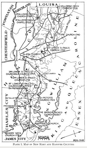
This map is oddly positioned. As it currently sits, the names of the parishes are properly displayed (from bottom to top, Waraney Church, Broken Backed Church, St. Peter’s Church, Lower St. Paul’s Church (3 of them), Slash Church, Upper St. Paul’s Church, and Fork Church), but the county names are sideways. However, the compass arrow in the lower right corner indicates that you have to rotate the map 90 degrees counterclockwise to have “north” be at the top of the map, a more normal map configuration; when you do that, the county names are upside down and the parish names are sideways. Like this:
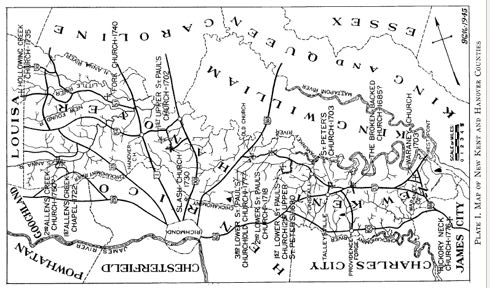
Why would anyone draw a map like this? Once you figure out which way is up, the map can help make sense of what was going on in central Virginia in the first half of the 18th century.
The Vestry books of St. Peter’s, St. Paul’s, and St. Martin’s churches have helped me understand my ancestors in Hanover County. The official records of Hanover County were destroyed when Richmond was burned at the end of the Civil War. The County Clerk (along with other clerks throughout Virginia) had sent the records to Richmond “for safe-keeping,” in anticipation of raids by the occupying Federal forces in the area. The retreating Confederate army had set fire to Richmond in order to deter the encroaching Federal troops under the command of Ulysses S. Grant. As a result, the old parish records are the best remaining sources of a variety of transactions in Virginia – births, marriages, deaths, land transfers, and so forth.
A brief survey of these vestry books reveals that my Hanover County ancestors were deeply involved in parish affairs. I will leave the Vestry book of St. Peter’s to my essay on New Kent County. The Vestry Book for St. Paul’s mentions various members of the Anderson family hundreds of times. Other family names are referenced less often: Hunt, more than a dozen times; and Hester, about a dozen times. The Vestry book does not mention the Walton surname at all, although I know that members of this family were significant property-owners and county officeholders during this time period.
My Ancestors in Hanover County
This set of Hanover County ancestors represents my father’s side of the family. The key family name is Walton; if you have been reading this set of essays, you may recall these people from other essays. I wrote about them in Weeks 9 and 15, in my essays on Cumberland County, Virginia and Boone County, Kentucky. I’ll be writing about them again in Week 31, when I write my essay on New Kent County, Virginia.

The earliest Walton I can say anything definite about is my 7th great-grandfather Edward Walton, Jr. (1672-1720). He was born in New Kent County, Virginia, and I’ll talk more about him when I write about that county in Week 31. The key figure for the Hanover County part of my story is Edward’s youngest child, John Walton (1709-1772). Both of his parents died when he was about 10 years old (his mother in 1717 and his father in 1720), and I haven’t been able to figure who raised him until he was ready to live on his own. His four oldest siblings were adults when their father died, and the three younger children (13-year-old Elizabeth, 11-year-old John, and 10-year-old Martha) probably lived with them. Edward’s younger brother, Robert, was also living in New Kent County and might have helped support the young orphans.
John Walton married Mary Sims (1718-1804) in Hanover County in 1735. Mary was born in the part of New Kent County that would become Hanover County in 1721. John and Mary had 12 children, including my 6th great-grandfather Simeon Walton (1741-1798), who was their fourth child. Their first four children are noted as being born in Hanover County, whereas records indicate that their last six children were born in Louisa County. Louisa was formed from Hanover County in 1742. I don’t think the family moved in these years.
Simeon married Agnes Hester (1746-1821) in 1763. Agnes had been born in Louisa County — probably in the part of the county that had been Hanover just a few years earlier. Simeon and Agnes had 13 children, including my 5th great-grandfather John Walton (1765-1840), who was their second child. It is difficult to figure out exactly where Simeon and Agnes lived; their children are identified as having been born in Amelia, Hanover, and Louisa Counties over the years, and it’s hard to identify a pattern. I do know that Simeon became pastor of a Baptist church in Nottaway County (west of Amelia) in the 1780s, and that they moved to Kentucky in 1795.
I’ll tell the stories of the families that married into the Walton family – Sims and Hester and their ancestors – in weeks 20 and 31, in essays on James City County and New Kent County.
The following set of Hanover County ancestors represents my mother’s side of the family. The key family name is Hunt; if you been reading this set of essays, you may recall these people from other essays. I wrote about them in Week 14, in my essay on Greenville County, South Carolina.
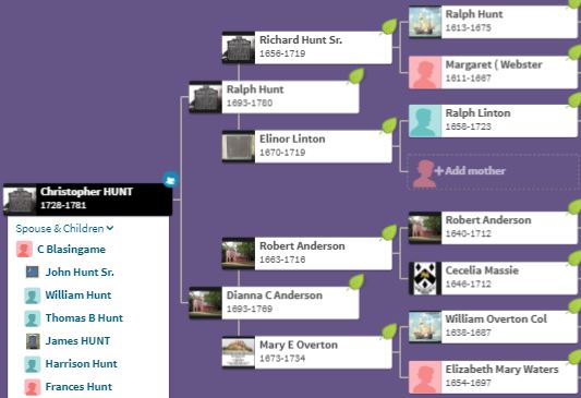
The earliest Hunt ancestor I can document is my 8th great-grandfather Ralph Hunt (1613-1675), who came to Virginia in 1635 and settled in Charles Parish (York County). His grandson and my 6th great-grandfather, also named Ralph Hunt (1693-1780), was the first of his line to live in Hanover County. He was born in New Kent County and married Dianna Charity Anderson (1693-1769) there in 1718. Records refer to her as “Charity,” so that’s what I’ll call her. Ralph and Charity had 10 children, who appear to have been born in a number of counties in southern Virginia – including Lunenburg, Halifax, and Hanover – and I don’t have an explanation for these discrepancies. My 5th great-grandfather, Christopher Hunt (1728-1781), was born in Hanover County; he was their sixth child. Ralph and Charity both died in Hanover County, so the Hunt family must have maintained some kind of constant presence there over the years.
Charity’s mother, Mary E. Overton (1673-1734), was born in New Kent County. She married Robert Anderson (1663-1716) in 1690 in New Kent, but this was almost certainly the part of New Kent that became Hanover County in 1721. The Anderson family is historically associated with Hanover County; the family home, Goldmine Plantation (named after a nearby creek), was in Hanover County, near Ashland. The Anderson surname is mentioned more frequently than any other of my family surnames in Hanover. The Andersons were large landholders and significant county officials in the history of Hanover County.
One well-known Anderson in Hanover was my 2nd cousin 7x removed Richard Clough Anderson, who joined with fellow Hanover County resident Patrick Henry to raise an infantry company for the Continental Line in 1775. Richard participated in the battles of Long Island and Trenton, wintered at Valley Forge, and was captured at Charleston. He was wounded twice – once at Trenton and a second time at Savannah. He served as aid-de-camp to General Nelson and was present at the surrender at Yorktown in 1781. Richard moved with his family to Kentucky after the war, where he served as surveyor of the Virginia Military Land District in the 1780s and participated in the process by which Kentucky became a state in 1792.
Another well-known Anderson connected with the Hanover County family was Robert Anderson, who was the son of Richard Clough Anderson (and my 3rd cousin 6x removed). After graduating from West Point in 1825, he had a a distinguished military career that spanned the Second Seminole War in Florida in the 1830s and the Mexican War in the 1840s. He was appointed to command a small US force at Ft. Moultrie, outside of Charleston in the winter of 1860. Finding that fort indefensible, he moved his troops to Ft. Sumter, where he held out for two days against a confederate attack led by Confederate General Beauregard. Unable to maintain his position, he surrendered to General Beauregard. Although no lives were lost during this engagement, the attack on Ft. Sumter kicked off the four-years Civil War.

An informative, detailed post. Particularly love the evolution-of-the-county maps. I also like the concept of a geographic family tree — grouping ancestors by where they spent time. I may try that as I analyze my research.
LikeLike
Glad you enjoyed it. I’m 17 weeks into this project and I am learning a boatload about my family tree.
LikeLike
I like this idea too, and you’ve got great information here for anyone researching this area. I agree that is a confusing, but important, map showing the county/parish relationships. Very funny to look at it ‘right side up’.
LikeLike
It took me a while to figure out that right side up was actually upside down!
LikeLike